LANDMATE/GERICS scientist presents the land cover change dataset LUCAS LUC at the AMOS 2021
Dr. Peter Hoffmann presented the newly constructed land cover change dataset LUCAS LUC at the virtual Annual Conference of the Australian Meteorological and Oceanographic Society ( AMOS 2021 ).
The LUCAS LUC dataset was initially developed for the European domain within the HICSS project LANDMATE and the WCRP-CORDEX FPS LUCAS . It provides historical and projected changes in 16 land cover classes (i.e. plant functional types) from 1950 until 2100. This was achieved by combining the high-resolution global land cover dataset ESA-CCI LC with land use changes provided by the Land-Use Harmonized Dataset Version 2 (LUH2) and using a newly developed land use translator.
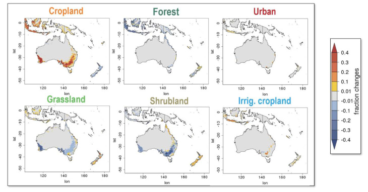
Peter Hoffmann applied the LUCAS LUC method to the Australasia domain and presented the resulting land cover changes. During the conference, he was able to discuss the method and the produced dataset with leading climate scientists from Australia and New Zealand. There is a strong interest in including land cover change into regional climate modelling studies for the Australasia domain, which shows the potential for the use of the LUCAS LUC dataset in regions outside of Europe.
Hoffmann P, Reinhart V, Böhner J, Rechid D (2021) Land use and land cover changes in Australasia based on ESA-CCI LC and LUH2 for use in regional climate modelling. AMOS Annual Conference 2021 (virtual), 8.-12.2.2021, Australia (Abstract book: https://amos.eventsair.com/amos-2021/abstract-book)

Figure: Land cover changes from 1950 to 2015 based on the LUCAS LUC dataset.

